Fișier:Israel - Location Map (2012) - ISR - UNOCHA.svg
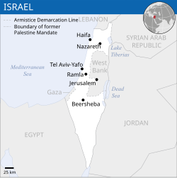
Mărește rezoluția imaginii (Fișier SVG, cu dimensiunea nominală de 250 × 250 pixeli, mărime fișier: 141 KB)

Randează această imagine în .
Acest fișier se află la Wikimedia Commons. Consultați pagina sa descriptivă acolo.

Descriere fișier

Descriere
English: Locator map of Israel.

العربية: خريطة إسرائيل.
Dată
Sursă
English: [1], OCHA, UNCS
Autor
Alte versiuni
SVG dezvoltare
InfoField
 
Sursa acestui fișier SVG este validă.
 
Această imagine vectorială a fost creată cu Inkscape.
 
 This map uses embedded text that can be easily translated using a text editor.

Licențiere

w:ro:Creative Commons
atribuind
Acest fișier a fost eliberat sub licența Creative Commons Atribuire 3.0 Neadaptată.
Atribuire: OCHA
Sunteți liber:
  • să partajați cu alții – aveți dreptul de a copia, distribui și transmite opera
  • să adaptați – aveți dreptul de a adapta opera
În următoarele condiții:
  • atribuind – Trebuie să atribuiți opera corespunzător, introducând o legătură către licență și indicând dacă ați făcut schimbări. Puteți face asta prin orice metodă rezonabilă, dar nu într-un fel care ar sugera faptul că persoana ce a licențiat conținutul v-ar susține sau ar aproba folosirea de către dumneavoastră a operei sale.
This map is part of a collection of 216 free country maps, created by the UN Office for the Coordination of Humanitarian Affairs (OCHA), to be used in print, web or broadcast products.

The ReliefWeb Location Maps released here are maps that highlight a country, its capital, major populated places and the surrounding regions.

Attribution Requirements

Using the map without modifications: ensure that the sources and the disclaimer are below the map. Credit as follows: "Credit: OCHA".

For use with alteration: remove the OCHA logo and disclaimer following any modification to the map, but keep the data sources as mentioned below the map. Credit the modified map as follows: "Based on OCHA map". You are responsible for the content of your map.

We are keen to receive your feedback and hear how you used OCHA's maps. We would be grateful if you would notify us by e-mail and share your work with us.

UN Disclaimer
The designations employed and the presentation of material of this map do not imply the expression of any opinion whatsoever on the part of the Secretariat of the United Nations concerning the legal status of any country, territory, city or area or of its authorities or concerning the delimitation of its frontiers or boundaries.
VRT Wikimedia

Această operă este liberă și poate fi folosită de oricine în orice scop. Dacă doriți să reutilizați acest material, nu trebuie să cereți permisiunea atâta timp cât urmați cerințele licenței menționate în această pagină.

Wikimedia a primit un e-mail ce confirmă faptul că deținătorul drepturilor de autor a aprobat publicarea sub termenii menționați în această pagină. Corespondența a fost verificată de un voluntar VRT și salvată în sistemul VRT al Wikimediei. Aceasta este disponibilă utilizatorilor cu cont VRTS sub numărul 2014031410007248.

Pentru verificarea permisiunii sau orice întrebări legate de tichet, folosiți avizierul VRT. Legătura către tichet: https://ticket.wikimedia.org/otrs/index.pl?Action=AgentTicketZoom&TicketNumber=2014031410007248
Find other files from the same ticket: SDC query (SPARQL)


Textual information (e.g. timestamp) once visible in the image itself has been moved into the image metadata and/or image description page. This makes the image easier to reuse and more language-neutral, and makes the text easier to process and search for. Commons discourages placing visible textual information in images. All licenses accepted on Commons permit this type of modification as a derivative work. If attribution information were removed and the image is not public domain, replace this tag with {{Attribution metadata from licensed image}}.

беларуская (тарашкевіца)‎ | català | Deutsch | English | español | فارسی | français | galego | magyar | italiano | македонски | മലയാളം | português | русский | sicilianu | slovenščina | svenska | Indonesia | 中文 | +/−

Captions

Add a one-line explanation of what this file represents

Items portrayed in this file

subiectul reprezentat

image/svg+xml

Istoricul fișierului

Apăsați pe Data și ora pentru a vedea versiunea trimisă atunci.

Data și oraMiniaturăDimensiuniUtilizatorComentariu
actuală8 octombrie 2023 10:26Miniatură pentru versiunea din 8 octombrie 2023 10:26250x250 (141 KB)Trần Nguyễn Minh HuyFile uploaded using svgtranslate tool (https://svgtranslate.toolforge.org/). Added translation for vi.
27 iulie 2022 08:39Miniatură pentru versiunea din 27 iulie 2022 08:39250x250 (140 KB)Enkhsaihan2005File uploaded using svgtranslate tool (https://svgtranslate.toolforge.org/). Added translation for mn.
27 iulie 2022 08:38Miniatură pentru versiunea din 27 iulie 2022 08:38250x250 (139 KB)Enkhsaihan2005File uploaded using svgtranslate tool (https://svgtranslate.toolforge.org/). Added translation for mn.
28 martie 2022 03:48Miniatură pentru versiunea din 28 martie 2022 03:48250x250 (136 KB)NyilvosktFile uploaded using svgtranslate tool (https://svgtranslate.toolforge.org/). Added translation for id.
17 februarie 2022 17:21Miniatură pentru versiunea din 17 februarie 2022 17:21250x250 (134 KB)KurmanbekFile uploaded using svgtranslate tool (https://svgtranslate.toolforge.org/). Added translation for tr.
18 februarie 2016 00:27Miniatură pentru versiunea din 18 februarie 2016 00:27250x250 (130 KB)Wereldburger758Resized page to drawing. Removal watermark. Validation of image.
19 august 2014 05:21Miniatură pentru versiunea din 19 august 2014 05:21250x250 (185 KB)Pharos== {{int:filedesc}} == {{Information |description={{en|1=Locator map of Chile.}} |date=2013 |source={{en|1=[http://reliefweb.int/map/chile/chile-location-map-2013 Chile Locator Map (ReliefWeb)]}} |author={{en|1=[[w:en:United Nations Offi...

Următoarele pagini conțin această imagine:

Utilizarea globală a fișierului

Următoarele alte proiecte wiki folosesc acest fișier:

Vizualizați utilizările globale ale acestui fișier.

Informații